There’s many forecasts out there and some are better than others, but a lot of it comes down to which forecasts work best for the local area and how you read them and interpret the results.
We could go into loads of information about weather systems and wind gradients, but that’s not what this page is about and not information you necessarily need to begin with. Being able to interpret a forecast is the key.
Lets be honest, the only place to get an accurate forecast these days is online. Although newspapers, TV and radio do give forecasts, they are never going to be as accurate as the internet which is automatically updating every 15 minutes.
The weather forecasting websites use data measured from atmospheric conditions and compare it to those taken in the past which helps them predict the incoming weather. Whereas the wind forecasting websites calculate the data picked up from weather stations around the world to calculation air movement and predict which pressure systems are moving where, which in turn forecasts the wind.

When taking this into consideration, it’s no surprise that the wind websites aren’t very good at forecasting the weather and the weather forecasting websites aren’t good at predicting the wind.
The best websites…..
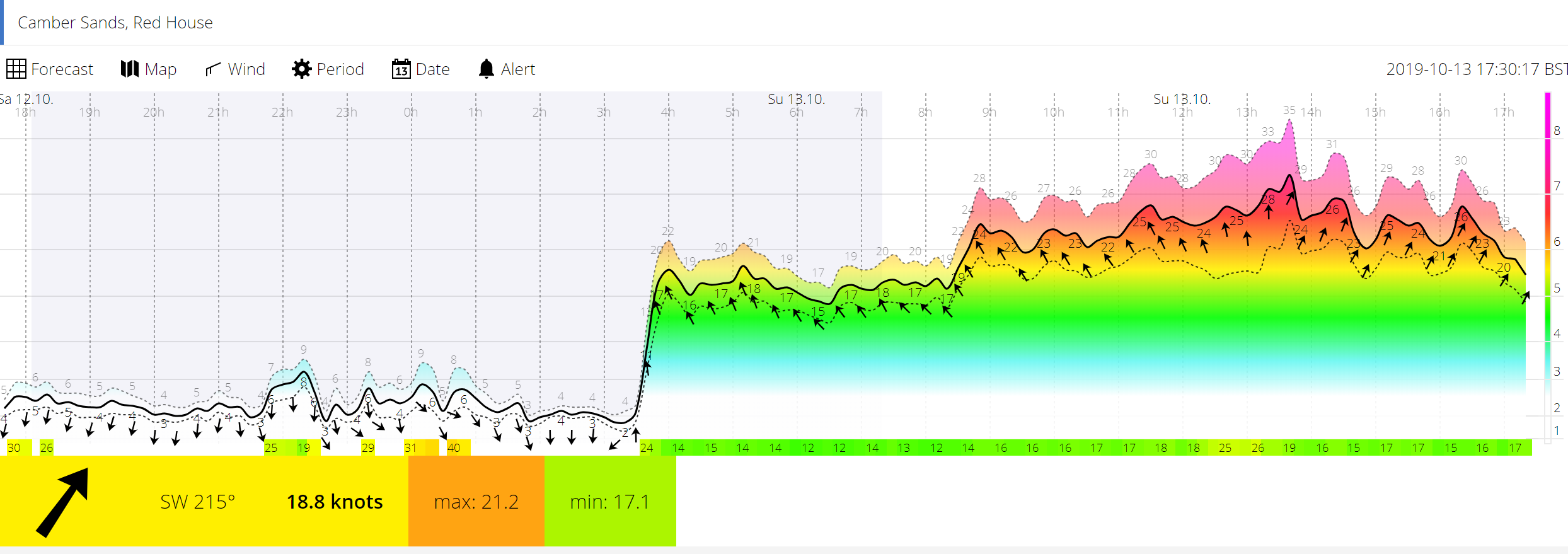
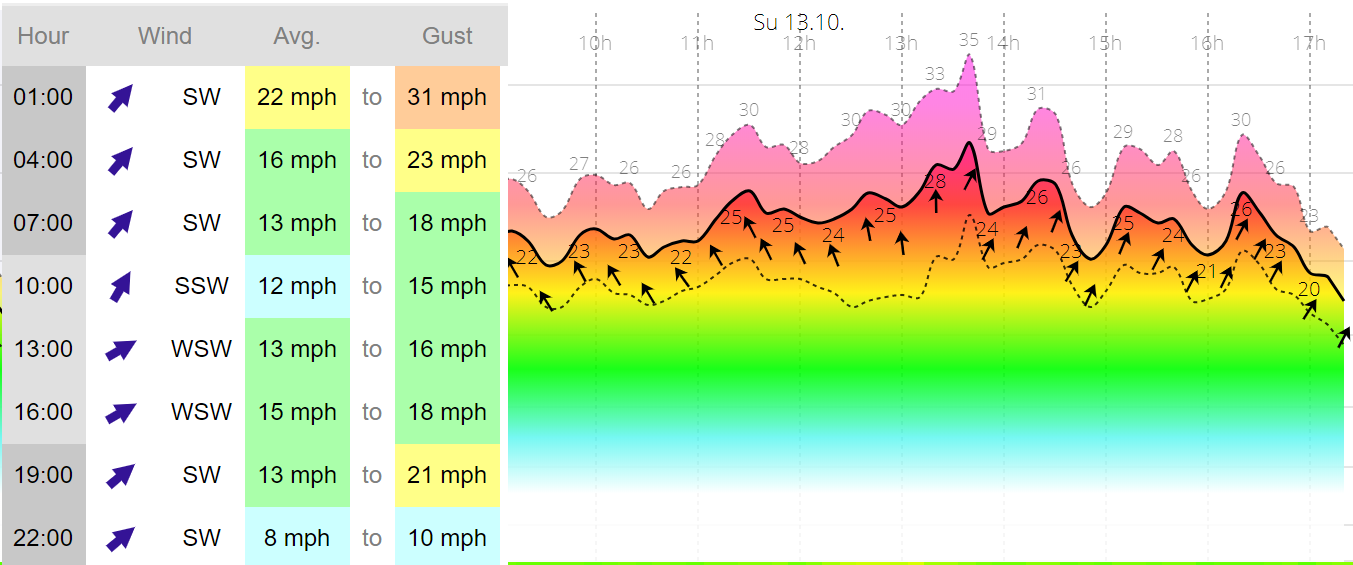
For the UK and south east coast (Camber Sands, Greatstone, Winchelsea, Pett, Pegwell Bay, Hastings & Hythe in particular), we find the most accurate website for forecasting the wind strength is www.xcweather.co.uk. This tends to be the best for the UK but may not work so well around the globe.
The website gives a break down of 3 hour intervals for the coming 8 days and an hourly breakdown for the coming 72 hours. Realistically, any forecast is only really accurate 24 – 48 hours in advance and even then it can change several times.
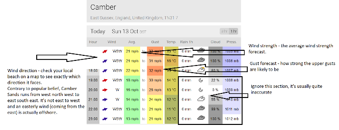
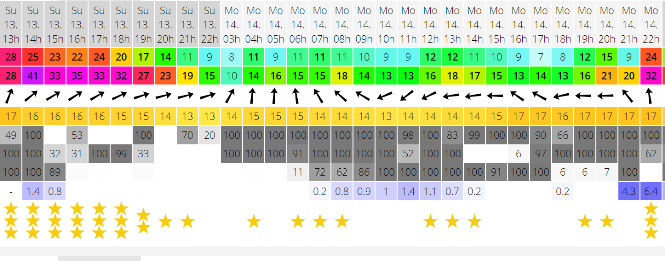
However, it isn’t as good as www.windguru.com for the wind direction, which tends to be spot on. Windguru isn’t as good as forecasting the wind strength as Xcweather but it does get the direction right most of the time. It gives several forecasts for the local area and it’s worth looking at them all to take an average. But again, ignore the weather and wind strength part, which tends to be inaccurate.
So, immediately you’re going to have to check at least 2 forecasting websites to get a good idea of what the wind will do. There are quite big discrepancies between various sites (up to 30%) so it’s worth spending the time to find the most accurate forecast for your local spot.
The problem is, all of the weather & and wind reports are just forecasts. They are predictions of what a super computer calculates will happen after analysing thousands of pieces of information. But they are often wrong. The more you look at the websites and compare what’s forecast to the actual wind or weather, the more you’ll see patterns emerging that usually repeat themselves.
Things to take into consideration:
Gusts from average wind speed
There’s always going to be variations in the wind when you’re kitesurfing but you don’t want them to be too big, especially when learning and progressing. If it’s forecast 20 knots with 30 knot gusts, that’s a potential 50% change in the strength, how do you choose a kite for that? The summer tends to have more steady stable winds with less variations but in the winter it can be very gusty. This is due to the big pressure systems (weather fronts) that we receive from across the Atlantic. I wouldn’t suggest going kiting in winds that have more than a 30% variation unless you’re experienced.
Weather
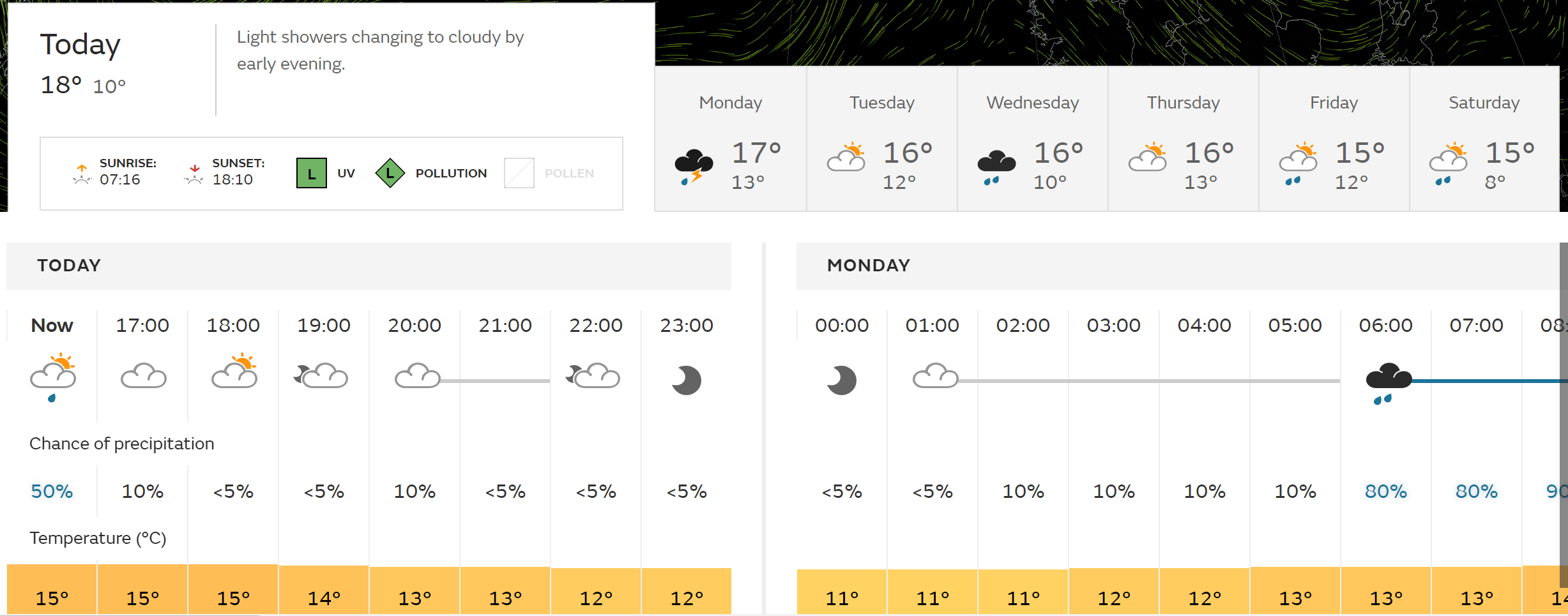
Believe it or not, the weather does affect the wind speed and direction, and it can be quite dramatic. So it’s worth checking a forecast before heading to the coast. For the UK there is no better localised weather forecast than the Met Office (www.metoffice.co.uk). It shows how much cloud cover there is, the percentage of sun, temperature and most importantly, if there is likely to be any rain / storms.
In the UK, if it’s forecast to be sunny with little cloud cover, there’s not much to worry about (other than a sea breeze – see below) and the conditions won’t change too much. If there are storms or clouds lurking, you need to be aware! A weather front (sometimes called a squall), which is effectively a dark or grey cloud can and does regularly change the weather. It can double the windspeed, half the windspeed, kill it off completely or change the direction by 180 degrees. If this is forecast then make sure you keep your eyes open when on the water or land your kite before it hits.
It can look something like the below images. Sometimes they aren’t menacing to the eye but can still change the weather significantly.

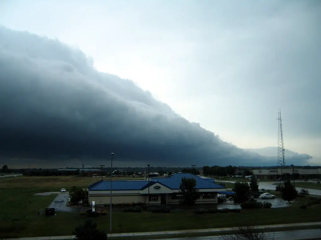
When a squall hits it can have a devastating effect but it’s often over within 5 – 10 minutes so it’s worth sitting it out and waiting for it to pass. Once they pass the wind will often return to normal after about 30 minutes.
The live speed compared to the forecast
One of the biggest mistakes we see is kitersurfers turning up to the beach thinking it’s 12m weather because it forecast 15 knots and they believe it is 15 knots. But it’s actually 25 knots and the forecast was wrong or it had changed. A lot beaches have a live wind reading now (www.thekitesurfcentre.com/weather) or you can buy a an anemometer (wind meter) to help you read the strength. These are a really useful tools and worth checking regularly. They help you master reading a forecast, as you get used to seeing what the forecast says and then what the live reading is actually reporting. This helps to figure out which directions your local forecast is best for and when it is and isn’t accurate.
If you don’t have access to a live reading, there are other signs you can look for when at the beach to give you an estimate of the wind speed. White caps on the water means it’s usually 14 knots or more and when a sea gull is able to hover without flapping their wings on a flat beach, it’s 22 knots or more.

Sea breezes
Camber Sands is renowned for it’s strong sea breeze all through the summer months and it’s kept us in business for the past 15 years. Without a seabreeze there is actually very little wind during the summer months and we’d never be able to run a kite school. A sea breeze can change a forecast from 10 knots to 35 and the problem with a sea breeze is that no one is able to forecast it. You have to do that yourself!
How to forecast a sea breeze – sun, clear skies and warm temperatures is the recipe for a good solid sea breeze. Camber Sands works best if there is a light wind forecast coming from the south west and clear skies in the morning, to allow the marshland behind the beach to heat up. There needs to be a temperature difference of at least 3 degrees between the water and the air, the sea breezes tend to be stronger in spring and up around mid September. After that the sea is usually warmer than the air so it doesn’t work, even on the sunny days.
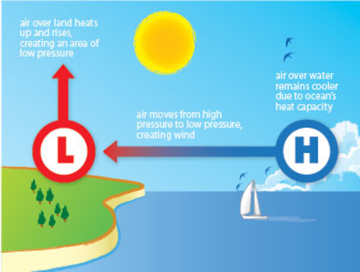
At Camber Sands we’re fortunate enough to have flat reclaimed marshland for around 12 miles behind the sea and then the old cliff line, which is a vertical cliff. The cliffs send any light south westerly breezes straight up in the air, to add to the already rising warm air, which starts the cycle that create a sea breeze (see how see breezes are created for more information). Other popular beaches have other similar local effects which is often why they have regular wind and are popular for wind sports.
So if you’re looking at a forecast, you need to look at the base wind speed, direction and the weather. The hard part is guessing how strong the sea breeze might be but the best way is to look at the ‘gust’ part of the forecast on xcweather and the take that as being your average wind speed.
With any forecast it’s about interpreting it yourself, building experience but most importantly, always take all your different sized kites to the beach as it’s often not going to be what you were expecting!